Hike to Bear Peak: The Best Summit in Boulder
The hike to Bear Peak is one of the best hikes in Boulder, offering some of the most incredible views of the city and a rewarding peak photo.

The hike to Bear Peak is one of the best hikes in Boulder, Colorado. It has everything I look for in a good hike: a good challenge that makes me feel accomplished afterward, the feeling of being right in the middle of nature, and incredible views from the summit. The Bear Peak Trail has all of that and more.
For more information on where to park, the Bear Peak Trailhead, difficulty level, and hot tips on for the Bear Mountain Hike, read on!
I use AllTrails Plus when I go hiking. I highly recommend it as you can download offline maps, and send out “lifelines” to friends and family to let them know exactly where you are. You can rate trails, and get inspired to try new ones. The membership is $35/year, but with this discount, it is just $25 for the year. That’s barely $2/month.
Click here to get 30% OFF of your own AllTrails Plus account
Use code: nickiposts30
Boulder Hiking Trail: Bear Peak Hike In Boulder Colorado
Check out my Bear Peak hiking reel on Instagram
Bear Peak is the second-tallest peak in Boulder, CO, the first being South Boulder Peak. It can definitely be difficult, especially the last hour going up, but once you reach the peak, you’ll be glad you did that for yourself! The Boulder Bear Peak is one of the best hiking trails in Boulder Colorado.

Must Hike Score: A must-do hike for Boulder locals and visitors alike
10/10
I absolutely love Bear Peak in Colorado. I had been saving this hike for a day when I was really ready for the challenge, as I had heard it was quite difficult. Once I finally did it, all I could think was ‘Why didn’t I do this sooner?’ It quickly shot up on my list of favorite Boulder hiking trails. That’s why I believe everyone who can, both locals and visitors, should definitely take advantage of this incredible summit right in our Boulder backyard.

Where is the Bear Peak Trail?
Click here for the Bear Mountain Hiking Trail Map on AllTrails.
Bear Peak is located on the south side of Boulder. The Bear Peak trails can be reached by several South Boulder trailheads such as the Cragmoor Road Trailhead, Shanahan Ridge Trailhead, NCAR, etc.

Virtual Tour of Bear Peak Out and Back
I totally think getting AllTrails+ is worth it. You can do virtual tours of all hikes, but this one is pretty cool to preview before going. You can really see the elevation g
ain and the intensity of the summit.
When To Do Bear Peak Hike
I hiked to Bear Peak in early October. The conditions were perfect. It was not too hot, there was no snow or ice, and the fall leaves were changing. I think you can probably do this hike all year round, with the exception of snowy days in the winter. The trail is very steep, so if you do want to hike up in the winter, I suggest bringing spikes. These are the spikes that I use for winter hiking.

Why Do Bear Peak Summit Hike
If you have the chance, I absolutely suggest hiking up to Bear Peak. It is very difficult and challenging at parts, but the sense of accomplishment once you reach the summit is grand. It makes everything worth it. Those swollen fingers. Those sore thighs. Worth it. Worth it for the incredible views and the sense of pride in completing something hard. I stand by my statement that the hike to Bear Peak is one of the most challenging, yet best hiking trails in Boulder.

How Much Elevation Gain is the Bear Peak Trail?
The elevation gain from parking at the Cragmoor Trailhead up to the summit is 2673 feet. The peak of Bear Peak sits at 8458 feet high. Check out the Bear Peak Boulder Trail Map to see the changing elevation as you go up.

Parking Trailhead Information for Bear Peak
There are three main locations where you can park in order to reach Bear Peak: Cragmoor Road, Shanahan Ridge Trailhead, and NCAR. You can find NCAR at the top of the hill, at the very end of Table Mesa Road. The Cragmoor Trailhead and the Shanahan Ridge Trailhead begin just a little bit lower.
Where do you Park for the Bear Peak Trail?
- NCAR– There are a ton of parking spots in this massive lot. Just drive as far as you can go on Table Mesa and you’ll easily find the parking lot.
- Cragmoor Road– Go west on Table Mesa, turn left on Lehigh, and then right on Cragmoor Road. The trail begins right at the end of the street. It’s obvious. You can park on the street.
- Shanahan Ridge– Go west on Table Mesa, turn left on Lehigh, and pass by Cragmoor Road. After the curve, you’ll see the trailhead on the right side of the road.

Where to Start Hiking the Bear Peak Trail
- NCAR– Park and walk to the right side of the building. The NCAR Trail will start here. Follow the NCAR Trail until it hits the Mesa Trail. Take the Mesa Trail south until it hits the Shanahan Fork Trail and go up. You can also go to Bear Peak via Fern Canyon. The Fern Canyon trail cuts to the right, just off of the Mesa Trail.
- Cragmoor Road– At the start of the trail, you can go immediately left or straight along the Cragmoor Connector.
- Shanahan Ridge– Follow the trail up along the Lehigh Connector until it hits the North Fork Shanahan Trail.
Bear Peak Trail Snapshot: Bear Peak Route Description
Here I’ll explain a bit about each section along the Bear Mountain Trail so you can have an idea of what you’re getting yourself into.
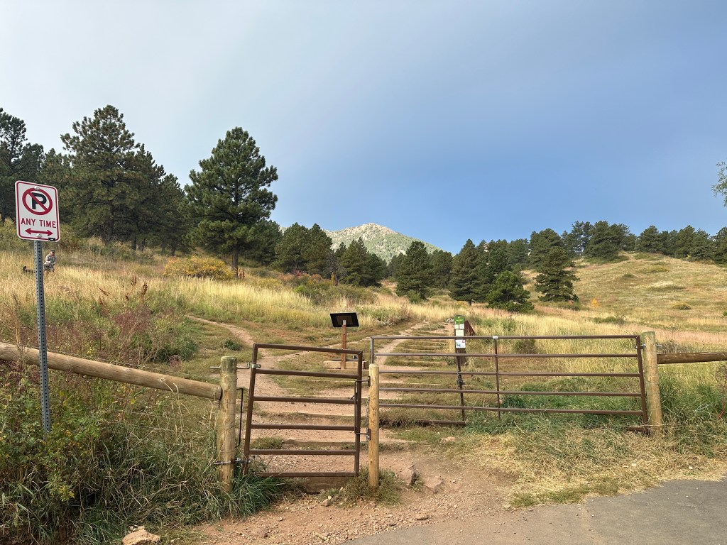
From the Cragmoor Trailhead
From the Cragmoor Trailhead, you’re immediately confronted with two choices. You can go up and to the left to get yourself quickly onto the North Fork Shanahan Trail. Or, you can go straight up the stairs, which you can see in the photo below. The stairs way is called the Cragmoor Connector. It really doesn’t matter which way you go as they’ll both lead you to your ultimate goal: getting onto the Shanahan Trail. Go with what your heart says.

Shanahan North Fork Trail
This section of the trail is pretty easy compared to the rest of the trail. The hiking trail is wide and well-manicured. No big boulders, just small pebbles. It is a steady incline, but nothing too crazy. This part of the trail is mostly forest-like and you’ll be walking through dense trees with a few sections without tree cover. You’ll appreciate that if it’s sunny. You’ll see many people walking their dogs along this path. You’ll also see some rock climbers, as The Slab, a popular climbing rock face, is at the very end of this trail before it turns to keep going up. You’ll be able to see The Slab rising up in front of you for several minutes. It’s massive and imposing.

Mesa Trail Junction to Nebel Horn
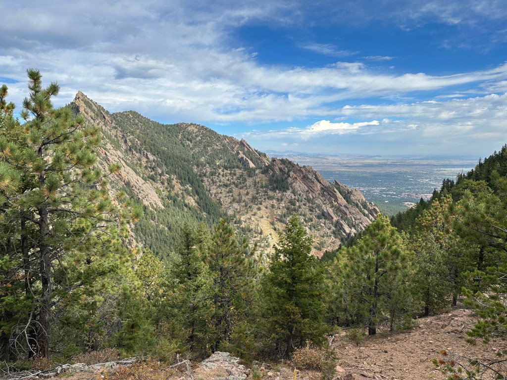
You’ll cross over the Mesa Trail, which is perpendicular to the Shanahan Mesa Trail. If you parked at NCAR, you’ll most likely be coming from the Mesa Trail. The last push to The Slab is still on a fairly nicely manicured trail. Once you reach The Slab, you’ll turn right and the trail starts to get thinner, more narrow, and more wild. Everything will suddenly feel very green. You’ll go down and cross over a small stream.
After the stream, the trail starts getting very steep. You’ll be hiking along narrow rock staircases, weaving in and out of boulders along the trail. If you start feeling tired, don’t worry, the last hour of the hike will get even harder! Keep following the trail up along Fern Canyon and you’ll eventually get to Nebel Horn. That is the large rock you’ll see to the right of the trail. You can take a small detour to go climb up on the rocks if you desire.

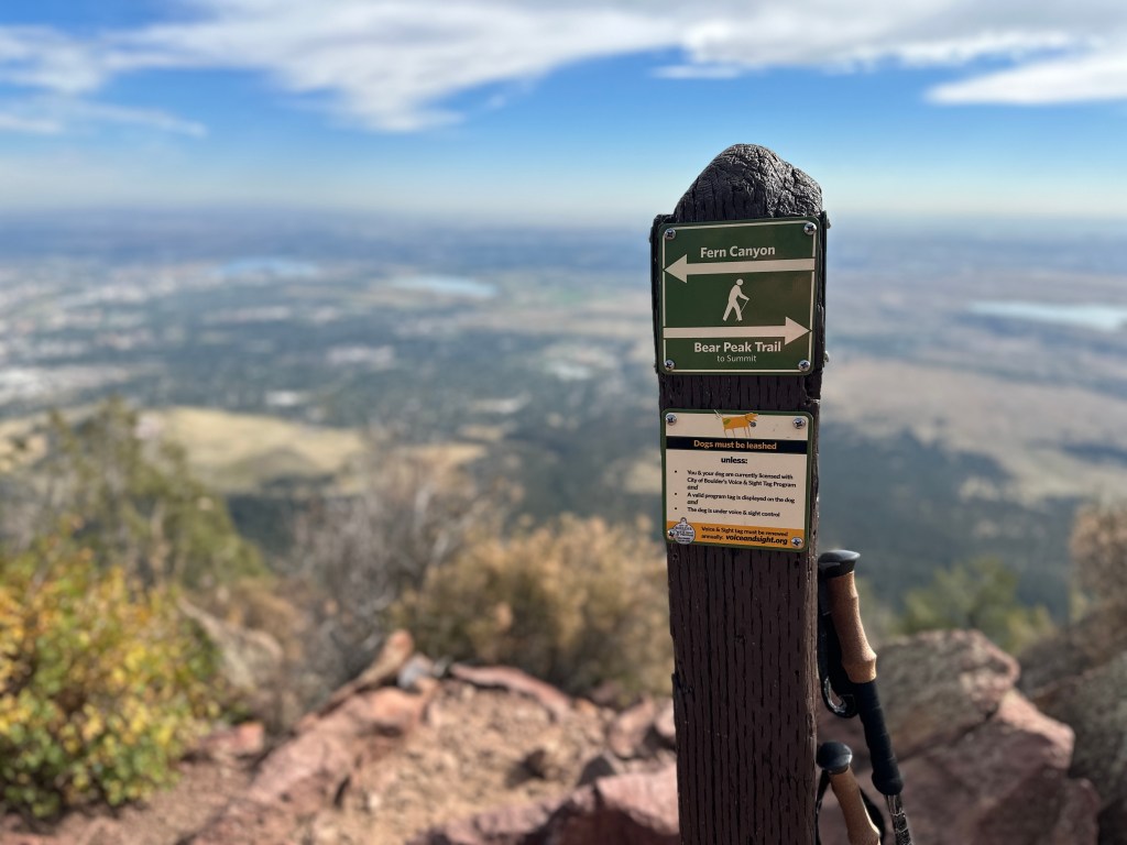
Nebel Horn to Bear Peak
Once you reach Nebel Horn, the whole area opens up a bit. It’s here that you’ll cross over to the other side of the ridge. You will get to see pretty incredible views of the Flatirons here. Bear Mountain hiking is no joke. Things are about to get serious from this point.
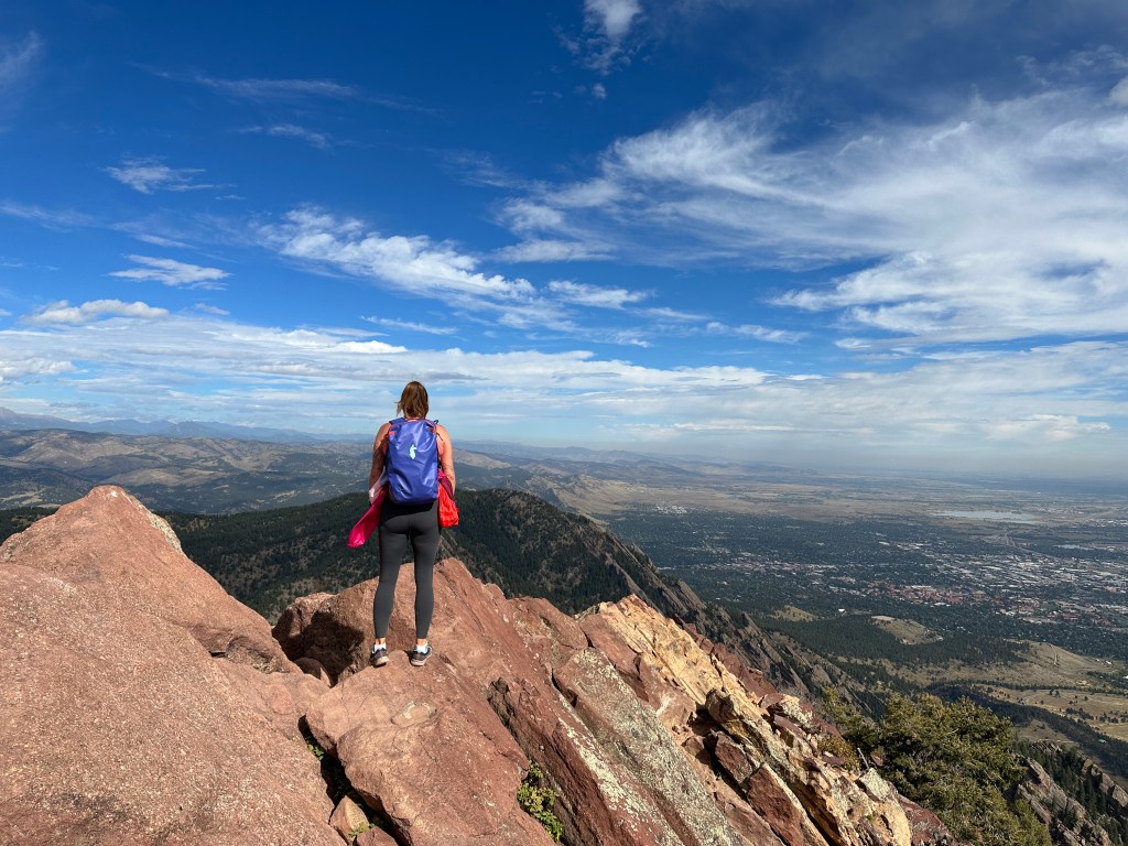
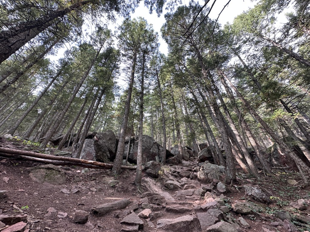
From Nebel Horn, you have about one more hour of pretty intense inclines. The last hour’s push is steep and full of rocky terrain, like in the photo below. You’ll need to use your hands at several parts along this portion. I had heard this last section was quite hard, so I made sure to conserve some of my energy once I reached this point. Just go slow and steady, you got this!
The very last push to reach the summit gets even rockier. Then to reach the true peak, you’ll need to scramble up several large boulders and maintain balance.

How Long is the Bear Peak Trail?
The Bear Peak via Shanahan Ridge Trail is 5 miles out and back. It took me about 2.5 hours to reach the peak, and then it took me about one hour to get back down to the car. But definitely make sure to budget some time up top because you’ll want to spend some time there eating snacks, taking photos, and admiring the views.
How Hard is the Bear Peak in Boulder?
It’s hard. The Bear Peak Trail is easily one of the most difficult hikes in Boulder, in my opinion. A large portion of the hike is incredibly steep and rocky terrain. You may want to bring walking sticks if you’re not accustomed to hiking and need a little balance help. You really just need to be prepared, mentally and physically, for that last hour of the straight-up rocky trail.

What to Wear when Hiking Bear Peak
The Bear Peak Trail in Boulder has a lot of varying terrain and it’s quite difficult, so you should dress accordingly to protect your ankles and knees along the trail, and your face from the sun. Here are a few suggestions:
- Strong athletic shoes/hiking boots
- shorts/pants – I love Kuhl hiking pants
- Athletic top that wicks away sweat
- Light jacket if you go early in the morning or in the evening (I LOVE the Cotopaxi windbreaker)
- Fleece in the winter or early spring.
- Sunglasses
- Hat- my favorite is from Cotopaxi
What to Bring when Hiking the Bear Peak Trail
Check out my blog post about the best hiking gear for beginners.
The entire hike may take you 3.5-5 hours, so don’t forget these things:
- Water bottle or Hydration Pack (2L minimum)
- Sunscreen SPF
- Hip bag (for keys and things)
- SPF Chapstick
- Step counter watch
- Your phone to take photos
Tips Resources for Hiking to Bear Peak
- Go early in the morning as this hike is long.
- Park in the NCAR parking lot, Cragmoor Trailhead, or Shanahan Ridge Trailhead.
- Remember to bring water and SPF.
- Dogs are allowed in the area, but only on a leash.
- Don’t forget to carry out your dog’s poo bags.
- Stand aside and let other hikers pass if they approach behind you quickly.
- Uphill hikers always have the right-of-way; stand aside for them.
- Take your trash with you. Leave no trace.
- It gets cold and windy at the peak.
- Pace yourself as the last hour is difficult.
How To Prepare For The Bear Peak Hike
If you’re new to Boulder, or not yet used to altitude, I don’t suggest doing this hike right away. Definitely do a few other hikes at slightly lower elevations to build up to this hike. Prepare yourself mentally as well as physically.
Are dogs allowed on the Bear Peak Trail?
Yes, this is a dog-friendly trail.
Are bikers allowed on the Bear Peak Trail?
BIcycles can go on the Shanahan Ridge Trail, but they won’t be able to go up through Fern Canyon and to the summit of Bear Peak.
The Best Bear Peak Trail Routes
There is not only one way to reach Bear Peak. Here are a few options for Bear Peak Boulder Routes.
Shanahan Ridge
I prefer this way up because there tend to be fewer people. It’s easy to find parking in the neighborhoods and I felt my car was safe here. The trail starts out steadily inclining but not too steep, so it was a nice transition to the more difficult parts of the trail.

Mesa Trail and Fern Canyon from NCAR
If you choose to park at NCAR, follow the NCAR trail up and just past the water tank. Once you reach the Mesa Trail, go left and follow it until you reach Fern Canyon. Turn right onto the Fern Canyon Trail and go up; this will eventually meet with the second part of the Fern Canyon and will bring you up to Nebel Horn.
Bear and South Boulder Peaks

Bear Peak and South Boulder Peaks are like twin sisters. The South Boulder Peak is technically taller, but Bear Peak is much cooler. The trail between the two peaks takes only 30 minutes so you can easily do both of these peaks in the same day, which is what I did.
If you prefer to hike up through Shadow Canyon, you can park at the South Mesa Trailhead. From there, go up through Shadow Canyon on the Towhee or Homestead Trails. You’ll then come to the Mesa Trail which you’ll walk along for a small section of the trail. You’ll eventually reach the Shadow Canyon Trail, passing the Devil’s Thumb on your right. You’ll then come to a junction where you can go left for South Boulder Peak, or right to Bear Peak. Why not do both?
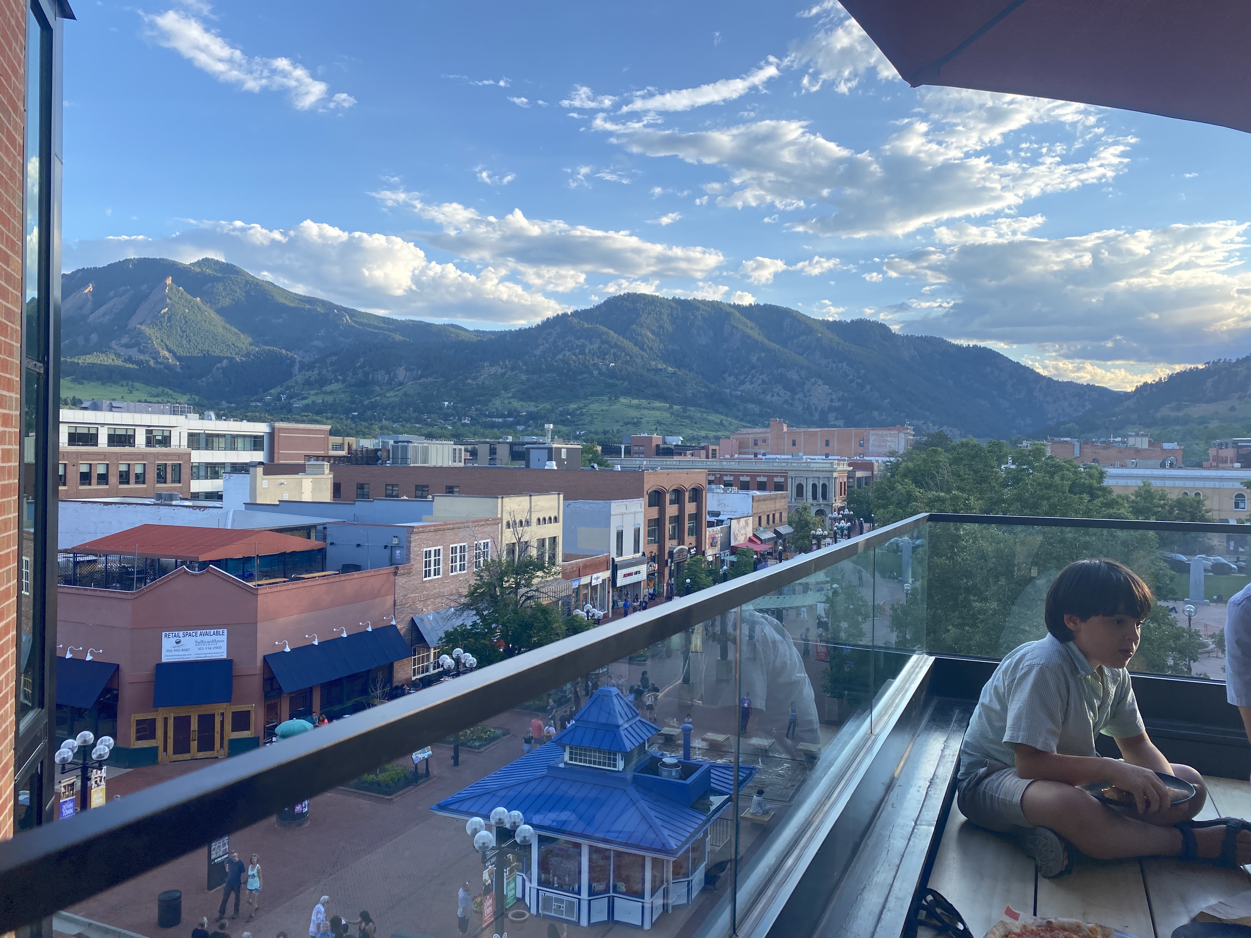
Where to Eat & Drink After Hiking the Bear Peak Trail
Southern Sun
You can find the Southern Sun at the corner of Table Mesa and Broadway, set slightly back from the main street. This is a brewery and restaurant with great beers and food. You can only pay in cash. No credit cards.
Address: 627 S Broadway Ste E, Boulder, CO 80305
Southside Walnut Cafe
If you go hiking early in the morning and want a hearty breakfast to follow, stop in the Southside Walnut Cafe.
Address: 673 S Broadway, Boulder, CO 80305
Where to Stay in Boulder near the Bear Peak Trail
If you have come to visit Boulder to be close to nature, here are a few suggestions for the area:
Fairfield Inn & Suites Boulder
Description: This hotel is located on South Boulder Road (Table Mesa) just next to the Highway 36 onramp. There is free parking, fitness center, and wifi. Continental breakfast is included.
Price: Rooms range in price from $160-$220 in the summer, and around $130-$200 in the winter.
Homewood Suites by Hilton Boulder
Description: The Homewood Suites is an apartment-style hotel with a swimming pool, kitchenette, and living room. You can also find BBQ grills near the swimming pool area.
Price: Rooms are around $250 – $350/night in the summer and can go as low as $150/night in the winter.
Colorado Chautauqua Cottages
Description: The cottages are located inside the Chautauqua Park, just near the base to many hikes as well as the Chautauqua restaurant. There is a summer concert series in the park as well. The cottages include a living room and a front porch. There is free wifi, parking, and breakfast for an additional charge.
Price: A cottage runs about $350/night in the summer months, and $200- $250 in the winter.
Bear Peak Trail Final Thoughts
You should absolutely not miss this trail. Yes, it’s hard. Yes, it’s challenging. But yes, it is also completely worth it! I think this is easily one of the best hiking trails in Boulder CO, and if you have the opportunity to hike to Bear Peak, seize that moment!
You can find this post featured at Trip101, along with several other great hiking spots in Colorado.


TRAVELING SOON?
INSURANCE: Cover yourself with travel medical insurance by SafetyWing.
FLIGHTS: Get the best flight deals with Skyscanner and set flight alerts with Hopper.
STAYS: Check out hotels and apartments with Booking.com and Vrbo.
RENTAL CARS: Get the best deal on rental cars with Discover Cars or RentalCars.
GOING HIKING? Get a 30% discount off your yearly AllTrails+ Account (code: nickiposts30)
eSIM: Get an international eSim with Airalo.
CITY GUIDES: Save time and purchase pre-made city guides with Thatch.
CITY TOURS: Book your tour with GetYourGuide and Viator
LUGGAGE: Get the best carry-on suitcase here.
CREDIT CARD: Start earning travel points with the best travel credit card.
BUENOS AIRES GUIDE: Purchase my Buenos Aires travel companion here.
CONSULTATION: Book a 1:1 travel consultation with Nicki here.
SUBSCRIBE: Get the Nicki Posts Travel Stuff newsletter every month.
TRAVEL BETTER: Check out my Travel Tips and best Travel Resources pages.
MORE? Check out more on my LINKS page to find me in more places!


You must be logged in to post a comment.