First and Second Flatirons: Popular Hike Near Boulder
First and Second Flatirons Reading Time: 21 minutes
The First and Second Flatirons Hiking Trail in Boulder is one of the most well-known paths, and for good reason. While it is not one of the hardest hikes in Boulder, it certainly presents a challenge and a great day on the mountain.
If you’ve spent any time in Boulder County, then you know the constant references to the flatirons. Everything has taken the name. Churches. Car dealerships. Real estate agents. But you can also see the Flatirons from all over Boulder. Just look up to the west, and their imposing shapes rise above Chautauqua Park. The best way to get to know the Flatirons is to see them up close. This blog post will tell you everything you need to know about hiking to the first and second Flatirons in Boulder, CO.
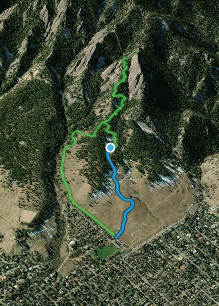
This hike is a combination of an out-and-back trail and a small loop.
I use AllTrails Plus when I go hiking. I highly recommend it as you can download offline maps, and send out “lifelines” to friends and family to let them know exactly where you are. You can rate trails, and get inspired to try new ones. The membership is $35/year, but with this discount, it is just $25 for the year. That’s barely $2/month.
Click here to get 30% OFF of your own AllTrails Plus account
Use code: nickiposts30

First and Second Flatirons: Boulder Hiking Trail
Check out my First and Second Flatirons hiking reel on Instagram.
The First and Second Flatirons Trail is one of the more well-known hiking trails in Boulder CO. In summer and on weekends, you’ll find it full of locals. You can hike it in the winter as well, just make sure to bring your spikes, as there are several sections where snow sticks around. There are also a few points where you’ll need to scramble a bit, which you should be aware of in advance.
What are the Flatirons?
The Flatirons are the rock faces that you can find rising above Chautauqua Park. They have become the symbol of Boulder, CO. There are technically 5 Flatirons. The First Flatiron is the largest on the very right. Then the next Flatirons go in order from right to left. They are named for the flat shape of their surface- like an iron.

Are the Boulder Flatirons man-made?
No. The Flatirons were formed naturally about 290 million years ago. It is estimated that they became tilted as they are today about 80 million years ago.
Must Hike Score:
9/10
I strongly recommend this hike. It is the perfect length of time (less than 2 hours) and is moderate in difficulty. You’ll also catch some amazing views both along the way and at the very top. Do not miss this amazing hiking trail in Boulder CO.
Can you see the Flatirons without hiking?
Yes, you can see the Flatirons without hiking. The best place to view them is from Chautauqua Park in Boulder.
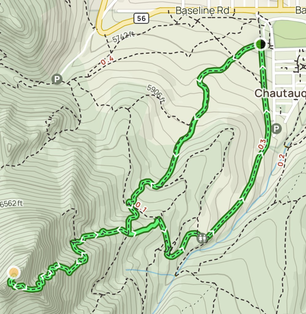
Where is the First and Second Flatirons Trail?
Click here to see the First and Second Flatirons Trail Map on AllTrails.
The First and Second Flatirons Trail is south of Flagstaff Mountain and north of NCAR; it is easily reachable via Chautauqua Park. The trail is just a short drive from downtown Boulder and easily walkable from the University of Colorado Boulder. You can easily find the trail at Chautauqua Park, which sits along the south side of Baseline Road, just before the road starts zig-zagging up into the Rocky Mountains.

Driving directions to Chautauqua Park
From Denver, take Highway 36 west. Get off at the Baseline Road exit. Follow Baseline West for about 5 minutes, crossing over Broadway Avenue. You’ll find the park on the left/south side of Baseline Road.
Driving directions to the First Flatiron Trailhead
See the above driving instructions. Head to Chautauqua Park. The trailhead begins just next to the ranger station.
How High is the First and Second Flatirons Trail?
The First and Second Flatirons Boulder elevation sits at 7251 feet high, with an elevation gain from Chautauqua Park of 1450 feet.
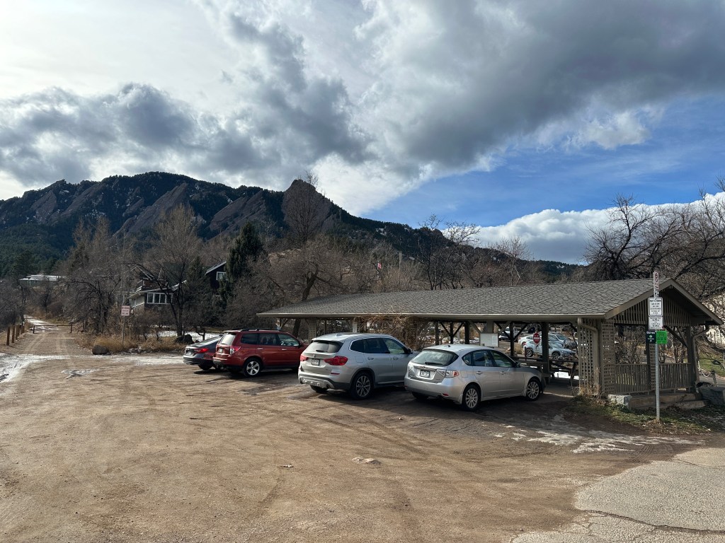
Where to park for the First and Second Flatirons?
Chautauqua Parking Lot
There is a ton of First and Second Flatirons Boulder parking. When you turn into the entrance of Chautauqua Park from Baseline Road, you’ll immediately see a small parking lot to the right. There is also parking all around the entire park loop. You need to pay for parking. You’ll need to follow the instructions on the posted sign to pay the parking fee.

Tip: For more Flatirons hike parking, turn left onto 12th Street from Baseline Road (when going west), the road will curve up to the right and lead you to another couple of small dirt parking lots (one on the right, and one on the left a little further up). But you’ll also need to pay here.
Baseline Road
There are several parking spaces along Baseline Road where you can park. Between Labor Day and Memorial Day (early September – late May) the parking is free. However, the opposite is true. From Memorial Day to Labor Day (May – September) you’ll need to pay for parking here.
Nearby Neighborhoods
You can also park in the residential neighborhoods on the north side of Baseline Road. On the streets closer to Chautauqua Park, the same parking fees exist and you’ll need to pay. However, if you are willing to park just a couple blocks away, the parking is free.
Where Does the First and Second Flatirons Trail Start?
The First and Second Flatiron Trail begins officially at the junction of the Flatiron Loop Trail and the Bluebell Trail connector.
The Flatirons Trailheads at Chautauqua
There are a few Boulder Flatirons Trails at Chautauqua Park, including the Baseline Trail, Meadow Trail, Bluebell Hiking Trail, and the Chautauqua Trail. The best trails to reach the First and Second Flatirons Trail are the Bluebell Hiking Trail and the Chautauqua Trail, which can be done as a loop. I took the Chautauqua Trail up until the Flatirons Trail and then took the Bluebell Trail down after I completed the Flatirons Trail.
Start the hike at the Chautauqua Trailhead, pictured below. It is just next to the ranger’s station. As you can see, there is a Flatirons Hike Boulder Map at the trailhead which you can consult before beginning the trail.

First and Second Flatiron Hike Trail Snapshot
As you can see in the photos below, there is a Flatirons loop trail that starts at the Chautauqua Trailhead and consists of both the Chautauqua Trail and the Bluebell Trail. At the junction, you’ll follow an out-and-back trail to reach the end of the hike at the peak of the First Flatiron. When doing the First and Second Flatirons hike in Boulder, you can choose whichever way on the loop you would like to go first.
First and Second Flatirons Hike Details
Chautauqua Trail
If you’re looking to see the mountains in Boulder Colorado, Chautauqua Park is one of the best places to do that. There are a ton of hiking trails that originate here.
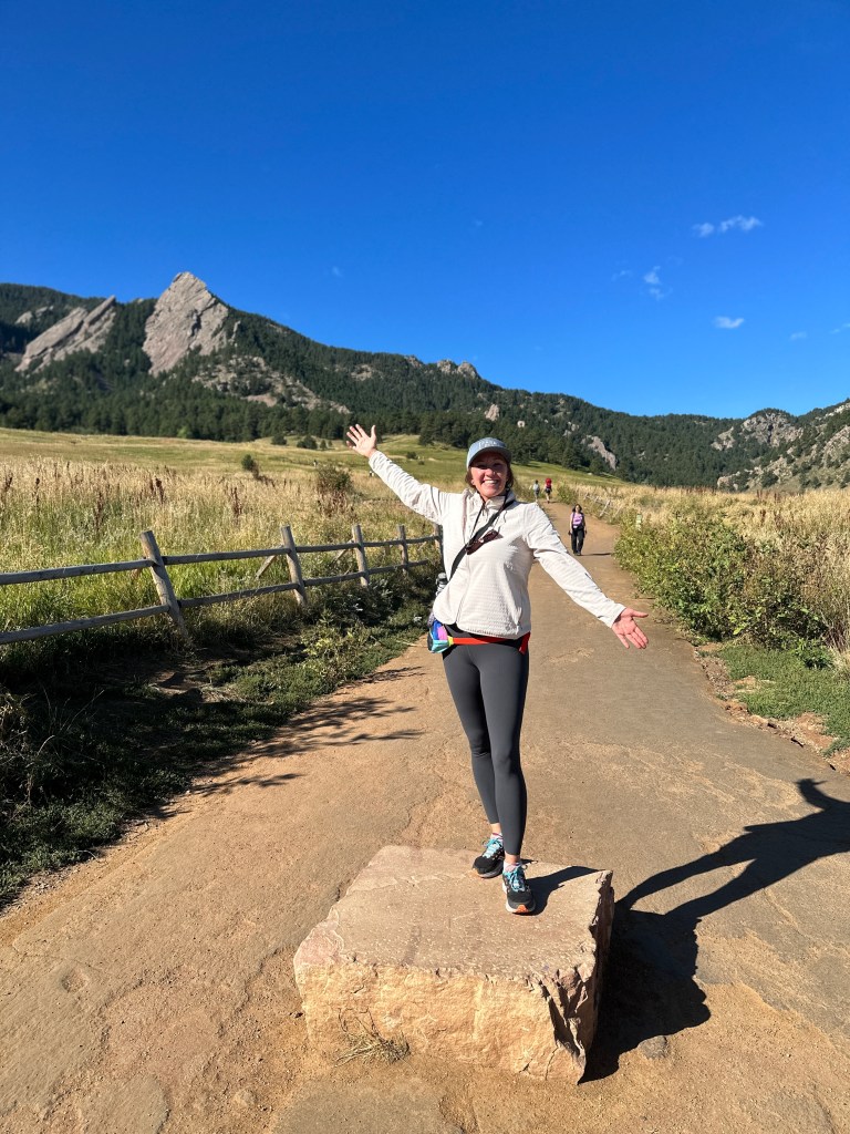
To begin the Boulder Flatirons Hike, start here at the Chautauqua Trail, which is reflected in the photo on the left. That photo was taken in late September 2023. It was still fairly warm out and there was no snow.
Take this trail up through the meadow (the trail behind me in the photo), and you will eventually enter into the trees. There are several switchbacks along the way.
When I hiked to the Flatirons in early December, the weather was very windy, and there was quite a bit of snow along the Chautauqua Trail. The first portion of the wide trail has even terrain. As you enter the forest, the terrain becomes quite rocky.
Getting to the First and Second Flatirons Trailhead
Keep following the Chautauqua Trail. The first trail sign you will come to has an arrow for the Bluebell-Baird Trail. When you get to that sign, go left at the fork. You will then immediately be confronted with another fork, which you’ll take to the right, following the signs for “2nd/3rd Flatiron (moderate).” The Bluebell-Bair Trail (easy) goes to the left.
Continue following that Flatiron Trail until you reach the sign in the photo below. This marks the junction where the out-and-back portion begins. As the sign indicates: “Out & Back/Return the way you came.”


First and Second Flatirons Trail
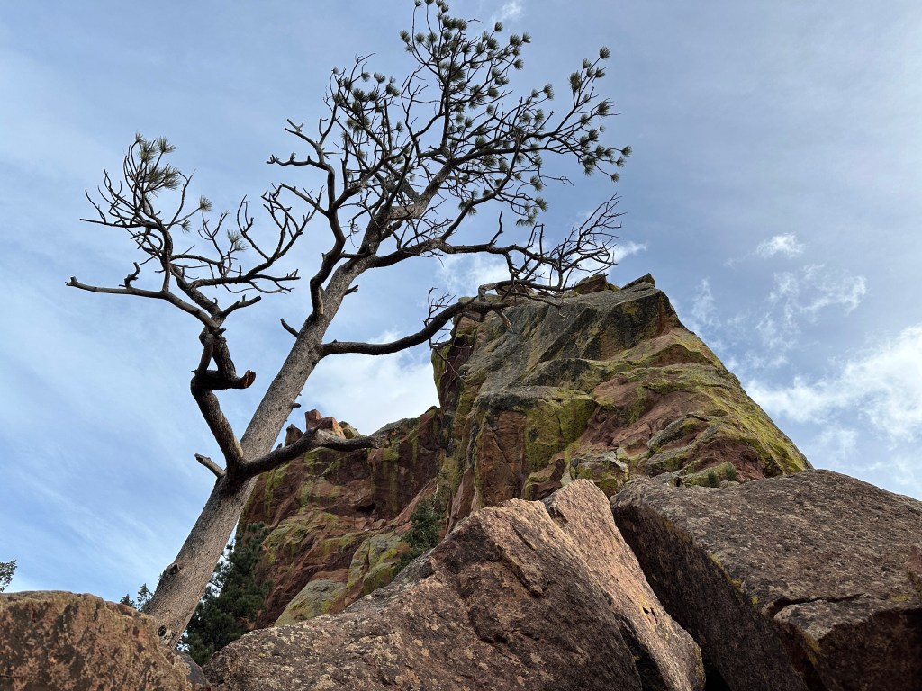
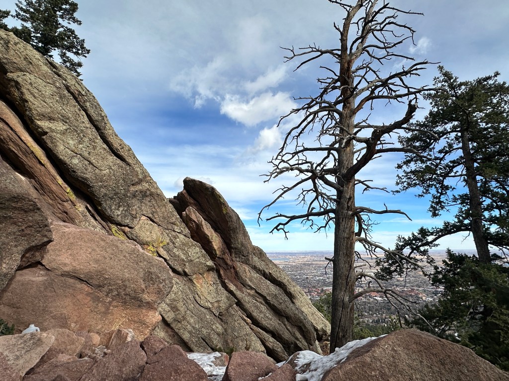
Continue along this path as it ascends. The trail becomes even more rocky, and steep. There are many points along the trail where you’ll be able to look up and see a ton of boulders on the slant rising above you on the mountainside. You’ll cross a few rock paths that reward you with amazing views of Boulder down below.
You will eventually come to a point where you’ll have to scramble. I personally find scrambles thrilling and wish hikes had more of them. But I want to warn you, as this can freak many people out. You’ll need both hands to scramble up. But at the top of the scramble, you’ll be rewarded with one of the best photo-taking spots.


Arriving at the First and Second Flatirons
As you continue up, you’ll follow the trail as it snakes along just next to the Second Flatirons to your left. There are a couple of lookout points where you can go off-trail to sneak a peak at the Second Flatiron. Once you begin to reach the end of the hike, you’ll follow the narrow trail as it rises against the First Flatiron to the right.
The trail seems to lose itself once you reach the Flatiron’s peak. From there you can climb on the red rocks until you reach the perfect photo spot, as pictured below. You’ll have your own little perch with a view of the top of the Third Boulder Flatiron.

Bluebell Hiking Trail
When you’re done with the amazing views, you can begin the descent the same way you came up. Continue until you reach the junction point again. From there, you can take the same trail you took up (Chautauqua Trail) or complete the loop along the Bluebell Trail.
This is the only part that is not marked in an obvious way. There are no signs. To get on that trail, take the very small, narrow trail that you can see pictured below to the left. Go about 3-4 minutes down. Then you’ll see another trail marker. Go right to get onto the Bluebell Trail. Just down below, you’ll see a structure which is the Bluebell Shelter.


From the Bluebell Shelter
The Bluebell Trail is very easy from here. The trail is wide with even terrain and small pebbles. The trail will look like the photo below from the Bluebell shelter until you return to the Chautauqua Trailhead, which is about 15 minutes. The photo below was taken in September and it is all still quite green. When I did this hike in December, there were several sections with snow along the trail.

How Long Does it Take to Hike First and Second Flatiron?
The total length of the First and Second Flatiron hike roundtrip is 2.7 miles. This trail took me about 2 hours and 15 minutes in total. I did spend some time hanging out and eating snacks at the peak so I could have completed the hike a bit quicker if I had wanted to.
How Hard is the First and Second Flatirons Trail?
So what is the First and Second Flatiron difficulty? I would say this question depends on the hiker. I hike quite a bit and found this trail to be easy. The trail signs along the trail indicate that it is “moderate.” There are a few steep sections, and one scramble, but other than that, I chugged along without much difficulty. If you’re a new hiker, this would be a good hike to try before attempting bigger hikes like Bear Peak or Green Mountain.
What to Wear when Hiking to the First and Second Flatirons
The First and Second Flatirons Trail in Boulder has a lot of varying terrain, so you should dress accordingly to protect your ankles and knees along the trail, and your face from the sun. Here are a few suggestions:
- Simple athletic shoes/hiking boots
- shorts/pants (I love Kuhl hiking pants)
- Athletic top that wicks away sweat
- Light jacket if you go early in the morning or in the evening (I LOVE the Cotopaxi windbreaker)
- Fleece in the early spring or fall. Down jacket in winter.
- Sunglasses
- Hat- my favorite is from Cotopaxi

What to Bring when Hiking the First and Second Flatirons Trail
Check out my blog post about the best hiking gear for beginners.
The entire hike may take you 2-2.5 hours, so remember these things:
- Water bottle
- Water bottle sleeve to easily carry your bottle without hands
- OR Hydration Pouch / Hydration bladder.
- Sunscreen SPF
- Hip bag (for keys and things)
- SPF Chapstick
- Step counter watch
- Your phone to take photos
Tips Resources for Hiking the First and Second Flatirons
- This is a busy trail, especially on weekends.
- Park in the Chautauqua parking lot for a fee.
- Extra parking at the top of 12th street, or in the residential areas for a fee.
- Free parking on Baseline Road between Labor Day and Memorial Day.
- Remember to bring water and SPF.
- Bring spikes in winter; there are some snowy parts.
- Go to the right side of the First Flatiron at the end of the trail for the best views.
- Dogs are allowed in the area, but only on a leash in most sections.
- Don’t forget to carry out your dog’s poo bags.
- Stand aside and let other hikers pass if they approach behind you quickly.
- Uphill hikers always have the right-of-way; stand aside for them.
- Take your trash with you. Leave no trace.

Are dogs allowed on the First and Second Flatirons Trail?
Yes, dogs are allowed on the First and Second Flatiron Trail. A leash is required in all sections within Chautauqua Park. Once you reach the trees, dogs must be on leash unless they have a voice and sight dog tag.
Are bikers allowed on the First and Second Flatirons Trail?
No. Bicycles are not allowed along any of these trails.
Looking for a Longer Hike? First and Second Flatirons Trail Add-ons:
There are a ton of trails that begin at Chautauqua Park, so I will mention just a couple below. You can find a whole list on AllTrails here.
Chautauqua Trail Loop
You can take the Chautauqua Trail from the parking lot and head directly towards the mountains along the trail right in the center of the meadow. Then, instead of going to the Flatirons, you can continue along the Bluebell Trail to make a full loop.

Royal Arch Trail
This is a challenging route up to the Royal Arch. Take the Bluebell Road Trail up until the Bluebell Shelter. From there, follow the signs to the Royal Arch.

Gregory Canyon Trailhead
From Chautauqua Park, take the Baseline Trail or the Meadow Trail until the Gregory Canyon trailhead. From there, there are a plethora of trails including Saddle Rock, which you can take up until Green Mountain. You can also take the Gregory Canyon trail up to Flagstaff Mountain.
Note: You can also reach the First and Second Flatirons via the Saddle Rock Trail. Take Saddle Rock to the EM Greenman Trail. From there, you’ll start to see trail signs pointing you to the First and Second Flatirons.
Where to Eat & Drink After Hiking the First and Second Flatirons Trail
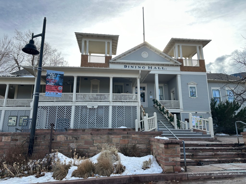
Chautauqua Dining Hall
If you’re enjoying your time inside Chautauqua Park, then stay for lunch at the Chautauqua Dining Hall. There is a great wrap-around outdoor balcony patio where you can enjoy your lunch with a view. They are open for breakfast, lunch, and dinner.
Address: 900 Baseline Rd, Boulder, CO 80302
Alpine Modern Cafe
This cafe is just down the street on the corner of 9th St and College Ave. It is clean, modern, and sleek with a great outdoor patio where you can sip on a post-hike cappuccino.
Address: 904 College Ave, Boulder, CO 80302
Where to Stay in Boulder near the First and Second Flatirons Trail
Colorado Chautauqua Cottages
Description: The cottages are located inside the Chautauqua Park, just near the base to many hikes as well as the Chautauqua Dining Hall. There is a summer concert series in the park as well. The cottages include a living room and a front porch. There is free wifi, parking, and breakfast for an additional charge.
Price: A cottage runs about $350/night in the summer months, and $200- $250 in the winter.

Hotel Boulderado
Description: This is a historic hotel in downtown Boulder, one of the town’s oldest. It’s located just one block off of Pearl Street. It is a 40-minute walk to Chautauqua Park, but you can also take the HOP (bus) counterclockwise to the stop on 9th/College (where Alpine Modern cafe is). From there it is a 10-15 minute walk to the park. There is a restaurant and bar on-site, though there are several around in the area as well.
Price: Rooms range in price from $250-$400 in the summer, and around $100 less in the winter.
BOOK NOW and stay in this historic downtown Boulder hotel
St Julien Hotel & Spa
Description: This beautiful hotel and spa is located on the corner of Walnut and 9th. It’s just a couple of blocks away from the Pearl Street walking mall. It’s a 25-minute walk to Chautauqua Park, or 15 minutes on the HOP between busing and walking. This is a luxury hotel with a swimming pool, valet parking, bar/lounge, fitness center, and bicycle rentals.
Price: Rooms range from $300- $500/night. In the winter you can find deals for around $250/night.
Check availability for this beautiful hotel & Spa downtown
Final Thoughts on First and Second Flatirons Trail
The Royal Arch Trail is easily one of the best trails near Boulder CO. It is easy to reach and there are a ton of other trails nearby. You could easily spend one entire week hiking the trails around Chautauqua Park. The summit of the Royal Arch will give you an amazing payout with incredible views of the city down below. I highly recommend doing this hike!

Pin the photos below to Pinterest for future reference:


TRAVELING SOON?
INSURANCE: Cover yourself with travel medical insurance by SafetyWing.
FLIGHTS: Get the best flight deals with Skyscanner and set flight alerts with Hopper.
STAYS: Check out hotels and apartments with Booking.com and Vrbo.
RENTAL CARS: Get the best deal on rental cars with Discover Cars or RentalCars.
GOING HIKING? Get a 30% discount off your yearly AllTrails+ Account (code: nickiposts30)
eSIM: Get an international eSim with Airalo.
CITY GUIDES: Save time and purchase pre-made city guides with Thatch.
CITY TOURS: Book your tour with GetYourGuide and Viator
LUGGAGE: Get the best carry-on suitcase here.
CREDIT CARD: Start earning travel points with the best travel credit card.
BUENOS AIRES GUIDE: Purchase my Buenos Aires travel companion here.
CONSULTATION: Book a 1:1 travel consultation with Nicki here.
SUBSCRIBE: Get the Nicki Posts Travel Stuff newsletter every month.
TRAVEL BETTER: Check out my Travel Tips and best Travel Resources pages.
MORE? Check out more on my LINKS page to find me in more places!


You must be logged in to post a comment.