Mallory Cave Hike: Best Views of the Flatirons
Mallory Cave Hike Reading Time: 17 minutes
The Mallory Cave hike has quickly risen to the top of the list of my favorite trails in Boulder, with good reason. It’s a sad day for Mount Sanitas, which was my previous number one! As a kid growing up in Boulder County, hiking the trails around NCAR was standard. But it wasn’t until I was an adult that I discovered the Mallory Cave Hike. I was absolutely blown away by the views from the top. It’s a great challenging intermediate hike as well. If you’re looking for a hiking trail near Boulder Colorado, read on for everything you need to know about hiking to Mallory Cave.
Click here to see my Mallory Cave reel on Instagram.
I use AllTrails Plus when I go hiking. I highly recommend it as you can download offline maps, and send out “lifelines” to friends and family to let them know exactly where you are. You can rate trails, and get inspired to try new ones. The membership is $35/year, but with this discount, it is just $25 for the year. That’s barely $2/month.
Click here to get 30% OFF of your own AllTrails Plus account
Use code: nickiposts30

Mallory Cave Boulder History
Mallory Cave sits at the top of Dinosaur Mountain, which can be easily reached along the trail from NCAR (National Center for Atmospheric Research). The first known reference to the cave was by some loggers cutting down trees in the area. Then in 1932, a CU Boulder student by the name of E.C. Mallory (hence the name Mallory Cave) heard about this bit of gossip and went on his own quest to find it and mark its location. Rather than tell everyone about his discovery right away, he decided to keep it a secret for a few years.

Must Hike Score:
9/10
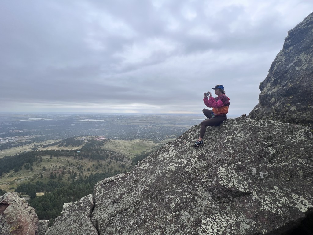
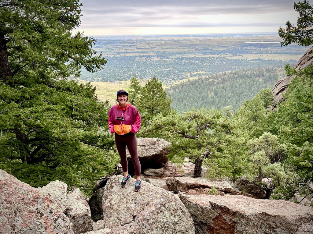
I wasn’t sure what to expect when I first started the Mallory Cave hike. But as I got higher and higher up, I fell more and more in love. You’re really treated to a special view once you reach the very top and look down. There are incredible views of the Flatirons and surrounding mountains, as well as a great view looking down on Boulder. I highly recommend this Mallory Cave hike.
Where is the Mallory Cave Trail in Boulder?
The Mallory Cave hike is a great hiking trail just above Boulder, CO. It is located on Dinosaur Mountain and can be reached from the NCAR parking lot. NCAR is that pink building atop a hill that can be seen from most places in Boulder. Driving directions are easy to reach NCAR; simply take Table Mesa Drive west until the end.
Click here to see the Mallory Cave Hike Trail Map.
Mallory Cave Hike Elevation
There is an 1174′ elevation gain on the Mallory Cave Hiking Trail from parking to peak. The highest point on the Mallory Cave hike is at 7076′ of elevation.

Mallory Cave Hike Trailhead
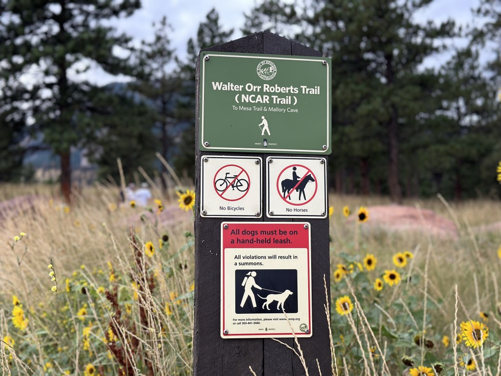
The official trailhead of the Mallory Cave hike begins at the photo you see below. You will first need to park at the NCAR parking lot. Then walk along the NCAR trail, and follow signs for Mallory Cave. You’ll find the Mallor Cave trailhead about 3 minutes after passing the water tank. The Mallory Cave trailhead begins just after you cross over the Mesa Trail junction.

Where to Park for the Mallory Cave Hike
Park at NCAR (National Center for Atmospheric Research). There are so many spaces that you will never have a hard time finding parking here. It’s very easy to reach. Take Table Mesa Drive west and keep going up the hill until it dead ends in the NCAR parking lot.

Take the bus
There is no public transport that will take you all the way up. But you can take a bus to get you close.
204
The 204 bus passes through part of Table Mesa in the Martin Acres neighborhood of South Boulder. Once it crosses over Broadway, it will continue up Table Mesa for several blocks before making a U-turn at Ithaca Drive. Get off the bus at the Ithaca stop. From the bus stop, it will be about a 45-minute walk up to the NCAR parking lot. However, it will only take about 15 minutes to reach the junction of the Table Mesa Trail and Bear Trail. The NCAR Table Mesa Trail will be the fastest route to take to reach the parking lot.
Where to Start the Mallory Cave Hike
Start the Mallory Cave hike at the NCAR parking lot. From the NCAR Trailhead, follow the signs for the NCAR trail which will eventually lead you to the start of the Mallory Cave hike trailhead.
What it’s Like to Hike to Mallory Cave
Start at the NCAR parking lot
The start of the hike is very calm. When you begin the trail from the NCAR parking lot, you’ll see the trail in the photo shown below. The trail map is shown on the right of the trail. In the photo below, you can see two women looking at the map. I suggest taking a photo of the map so you’ll have it with you as you hike, just in case.


The start of the trail is very easy. As you can see in the photo, it is a wide, relatively flat trail. You’ll walk on this trail for about 8 minutes, with a fantastic view of Bear Peak and Dinosaur Mountain in front of you. This is a very leisurely walk in the beginning.
Follow signs for Mallory Cave
Follow the signs that mention Mallory Cave. This will first lead you downhill (photo below) as you make your way into a valley. You’ll be able to see the Bear Trail at the bottom of the valley down below which goes up to Bear Peak. Stay on your trail, however, and it will curve around to the right. You’ll see the Flatirons in the distance to your left, as well as the road you drove to reach the parking lot in the distance in front of you.

The trail will then curve to the left and begin to get a little steep as you ascend the rocky terrain. You’ll continue going up for about 10 minutes until you reach the water tank.
Valleys, Water tanks, and Rocky Terrain
I always think it’s funny to run right into a massive water tank covered in graffiti as I walk through nature. But alas, it is there. The trail will go around the tank’s left side and continue on into another valley with fantastic views. After just a few minutes you’ll reach the first sign that doesn’t mention Mallory Cave (photo below on the left). Go left.


After just a few more minutes along the NCAR trail, you’ll cross over the Mesa Trail and see the official Mallory Cave hike trailhead. Things start to get a bit more challenging once you reach the Mallory Cave trail. The path will edge along the side of the mountain and enter into the tree-covered area.
The trail will begin to get more narrow and rocky. Make sure you have good footwear. The terrain gets tougher as you ascend, but luckily most of the trail is covered with trees so if it’s a hot day, you have a lot of shade.
You’ll know that you’re near the top of the trail when you look up to see a large flat rock face to your left (photo below). Give one last push to climb over the rocks and reach a flat area with signs about the bats.
The final push to reach the top
Once you reach the flat area where you’ll find signs about bats, it will feel like this is the end of the hike. From April 1- October 1, you cannot climb up to the cave. You’ll be able to see a net blocking it off. If you go in the fall or winter, you can climb up the steep rock face to approach the cave (though you cannot enter the cave).


Go to the right along the edge of the mountain to reach a great lookout spot above Boulder. You can get some really nice views and photos from here.
There is a small, rocky trail that is not very easy to see at first. But look around, and you’ll see it. It is very narrow, and the terrain is very rocky so take precautions while climbing up. It zig-zags back and forth as it makes its way further up Dinosaur Mountain. The trail will then lead you to the right where you can get some more incredible photos with the Flatirons behind you.
You can also climb atop many of the rocks, but be careful because it is a long way down if you slip.
Looking Down
As always, don’t forget to look down when you’re hiking. The views over Boulder are pretty spectacular. There are parts of this trail that feel really wild and not that worn, which is really special. From the top you’ll have great views over Boulder, and the Flatirons just behind you.
If you’re looking for Mallory Cave climbing, the Der Zerkle Crag is a great spot with good views. You can find it near the top.

Are there bats in Mallory Cave?
Yes! Townsend bats live in the Mallory Cave during the summer. In the fall and winter, they continue up to higher elevations leaving the cave empty.


Mallory Cave Closures
Because of the white-nose syndrome, the bats are well protected. This disease can wipe out an entire population of bats, so Boulder OSMP (Boulder Open Space and Mountain Parks) takes precautions to ensure this doesn’t happen. The cave entrance is closed all year.
The cave itself is always protected with bars that allow the bats to enter and exit, but humans cannot enter. The steep path up to reach the cave is blocked off and closed from April 1 – October 1. As you can see in the photo below, there is a mesh netting that blocks off the entrance. From October 1 – March 31, you can climb up to get closer to the cave, but you can never fully go inside it.

How Long is the Mallory Cave Hike in Boulder?
It took me about 1.5 hours to reach the peak from the parking lot. The trail was in and out, so I retraced my steps all the way back, which took just under one hour. I spent a lot of time eating snacks, admiring the views, and climbing on the rocks, so my total trip was about 4 hours. But it can easily be done in under 3 hours if you just go up and back. The official trail is about 1 mile long, but it’s a pretty steep trek. The total distancefrom the parking lot is 3 miles.

What is the Difficulty Level of the Mallory Cave Hike?
I would say the Mallory Cave hike is an intermediate-level hike. The first 30 minutes is fairly easy as it is mainly flat. The last hour gets a little harder as the ascend gets quite steep and there are a lot of rocks and boulders in the path. The last part of the hike is the hardest as the boulders are the largest and the path is most narrow. You may need to use your hands at several sections.
What to Wear when Hiking to Mallory Cave
The Mallory Cave trail in Boulder has a lot of varying terrain, so you should dress accordingly to protect your ankles and knees along the trail, and your face from the sun. Here are a few suggestions:
- Simple athletic shoes/hiking boots
- shorts/pants – I love Kuhl hiking pants
- Athletic top that wicks away sweat
- Light jacket if you go early in the morning or in the evening (I LOVE the Cotopaxi windbreaker)
- Fleece in the winter or early spring.
- Sunglasses
- Hat- my favorite is from Cotopaxi
What to Bring when Doing the Mallory Cave Hike
Check out my blog post about the best hiking gear for beginners.
The entire hike may take you 2.5-4 hours, so don’t forget these things:
- Water bottle
- Water bottle sleeve to easily carry your bottle without hands
- Sunscreen SPF
- Hip bag (for keys and things)
- SPF Chapstick
- Step counter watch
- Your phone to take photos
Tips for Hiking to the Mallory Cave near Boulder
- Go early in the morning as it gets very hot in the afternoon.
- Park in the NCAR parking lot.
- Remember to bring water and SPF.
- Many great photo opportunities around. They get better as you get higher.
- Dogs allowed in the area, but only on a leash.
- Stand aside and let other hikers pass if they approach behind you quickly.
- Uphill hikers always have the right-of-way; stand aside for them.
- Take your trash with you. Leave no trace.
- Don’t forget to carry out your dog’s poo bags.
- There are other easier trails nearby so you can change your mind if it feels too difficult.
- The Mallory Cave is closed between April 1 – October 1.
Looking for a Longer Hike? Mallory Cave Hike Add-ons:
There are TONS of hikes that go through this area and can be combined with more hikes to create a longer journey. I suggest taking a look at a map of the area as there are so many that I have not listed them all here.
The Mesa Trail Loop
The NCAR Mesa Trail makes a big loop around the area. The path goes perpendicular to the Mallory Cave hike and crosses over it right at the Mallory Cave trailhead. The loop goes through the valley and crosses Table Mesa to continue the trail. You can also make a slight detour to do the Skunk Canyon Trail.
Bear Canyon
The Bear Canyon hike will take you around the area, and you can combine it with the Bear Peak trail if you would like. You can see the Bear Canyon trail in the photo below as it winds through the valley.

Where to Eat & Drink After the Mallory Cave Hike
Southern Sun
You can find the Southern Sun at the corner of Table Mesa and Broadway, set slightly back from the main street. This is a brewery and restaurant with great beers and food. You can only pay in cash. No credit cards.
Address: 627 S Broadway Ste E, Boulder, CO 80305
Southside Walnut Cafe
If you go hiking early in the morning and want a hearty breakfast to follow, stop in the Southside Walnut Cafe.
Address: 673 S Broadway, Boulder, CO 80305
Where to Stay in Boulder near the Mallory Cave Hike
If you have come to visit Boulder to be close to nature, here are a few suggestions for the area:
Fairfield Inn & Suites Boulder
Description: This hotel is located on South Boulder Road (Table Mesa) just next to the Highway 36 onramp. There is free parking, fitness center, and wifi. Continental breakfast is included.
Price: Rooms range in price from $160-$220 in the summer, and around $130-$200 in the winter.
Homewood Suites by Hilton Boulder
Description: The Homewood Suites is an apartment-style hotel with a swimming pool, kitchenette, and living room. You can also find BBQ grills near the swimming pool area.
Price: Rooms are around $250 – $350/night in the summer and can go as low as $150/night in the winter.
Colorado Chautauqua Cottages
Description: The cottages are located inside the Chautauqua Park, just near the base to many hikes as well as the Chautauqua restaurant. There is a summer concert series in the park as well. The cottages include a living room and a front porch. There is free wifi, parking, and breakfast for an additional charge.
Price: A cottage runs about $350/night in the summer months, and $200- $250 in the winter.
Mallory Cave Hike Final Thoughts
This is my newest favorite trail to hike in Boulder, Colorado. The reward at the end of the hike is beyond worth it. I had so much fun climbing and playing on the big rocks at the top and admiring the view down below. You can also get a fantastic view of the Flatirons in the distance. This is what it truly feels like to be in nature. I loved every second of this hike. The Mallory Cave hike is an absolute must-do!


TRAVELING SOON?
INSURANCE: Cover yourself with travel medical insurance by SafetyWing.
FLIGHTS: Get the best flight deals with Skyscanner and set flight alerts with Hopper.
STAYS: Check out hotels and apartments with Booking.com and Vrbo.
RENTAL CARS: Get the best deal on rental cars with Discover Cars or RentalCars.
GOING HIKING? Get a 30% discount off your yearly AllTrails+ Account (code: nickiposts30)
eSIM: Get an international eSim with Airalo.
CITY GUIDES: Save time and purchase pre-made city guides with Thatch.
CITY TOURS: Book your tour with GetYourGuide and Viator
LUGGAGE: Get the best carry-on suitcase here.
CREDIT CARD: Start earning travel points with the best travel credit card.
BUENOS AIRES GUIDE: Purchase my Buenos Aires travel companion here.
CONSULTATION: Book a 1:1 travel consultation with Nicki here.
SUBSCRIBE: Get the Nicki Posts Travel Stuff newsletter every month.
TRAVEL BETTER: Check out my Travel Tips and best Travel Resources pages.
MORE? Check out more on my LINKS page to find me in more places!


You must be logged in to post a comment.