Mount Sanitas Trail: Best Hiking Trail in Boulder Colorado
Mount Sanitas Trail reading time: 15 minutes
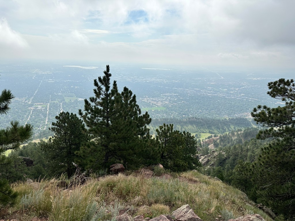
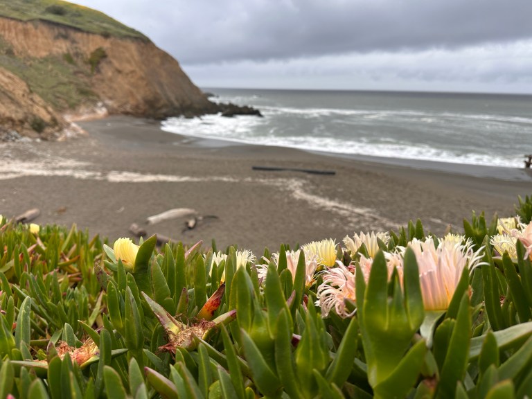
In my personal opinion, the Mount Sanitas Trail is one of the absolute best hiking trails in Boulder. There are two ways to reach the peak with varying levels of difficulty for the challenge you are seeking. The views from the top are stunning as you look down over Mount Sanitas Valley. Don’t miss out on the opportunity to hike one of Boulder’s best hiking trails.
Click here to see my Mount Sanitas reel on Instagram.
I use AllTrails Plus when I go hiking. I highly recommend it as you can download offline maps, and send out “lifelines” to friends and family to let them know exactly where you are. You can rate trails, and get inspired to try new ones. The membership is $35/year, but with this discount, it is just $25 for the year. That’s barely $2/month.
Click here to get 30% OFF of your own AllTrails Plus account
Use code: nickiposts30

Boulder Hiking Trail: Mount Sanitas
In middle school, we took a field trip to Mount Sanitas to learn about nature words such as plateau, valley, ridge, etc. It was my first time at Mount Sanitas, and the beginning of my love affair with the trail. I’ve hiked up to the peak both ways. I’ve run up it (when I was younger and fitter). I’ve admired its beautiful views from many angles. If I had to recommend one single trail in Boulder, this would be the one.
I’ve now done many of the Boulder OSMP (Open Space & Mountain Parks) trails and the Sanitas valley Loop Trail remains at the top of my list.
Must Hike Score:
10/10
For me this trail has everything. It offers a good challenge. Great tree cover. Good views. Alternative routes. It’ll definitely get your heart pumping.
Where is Mount Sanitas?
Click here to see a Mount Sanitas Trail map.

Mount Sanitas is located just outside of downtown Boulder. You can easily start the hike at the Sanitas trailhead at the top of Mapleton Street (north side of the street), just before the Centennial Trailhead. Mount Sanitas is just north of the Anemone Loop Trail and the Red Rocks Spur Loop Trail.
How High is Mount Sanitas? (Mount Sanitas Elevation)
The peak of Mount Sanitas sits at 6,800 feet high. The base of the trail is at 5530 feet, for an elevation gain of 1323 feet. If you’re not used to the high elevation of Colorado, make sure to drink lots of water and take it easy.
Mount Sanitas Trailhead
The Mount Sanitas trailhead is on the north side of Mapleton Street, just past the residential areas.
Where do you Park for Mount Sanitas?
There are three places where you can park in order to hike Mount Sanitas: The small Sanitas lot, the Centennial trailhead, and Mapleton Street. Driving instructions to reach the parking for Mount Sanitas are easy.
From Broadway, drive west uphill along Mapleton Street. Just after the hospital, there will be a small Mount Sanitas Trailhead parking lot on the right with about 8-10 spaces. If those spaces are full, continue along Mapleton for 1-2 minutes. On your left, you will find the Centennial trailhead parking lot. This lot has public restrooms. There are about 30 parking spaces here. If this lot is full, turn around and head back down Mapleton. You can usually find a parking spot along the street, and then you’ll just have to walk back to the trailhead.


Where to Start Hiking at Mount Sanitas
If you park in the small Sanitas parking lot, you will be able to see a small trail with a Mount Sanitas map and trailhead sign. Follow the path up several stairs and you’ll reach the junction between the Mount Sanitas Trail and the East Ridge Trail. Go left into the trees for a challenge, and right (towards the meadow) for a more leisurely hike. Refer to the photo below for visual reference.


If you park in the Centennial parking lot, you’ll need to cross the street. There is a small path that leads down towards a pavilion. Go through the pavilion. There you will see a fork in the path. Go up and left to start the Sanitas Trail (more challenging) or up and right to reach the start of the East Ridge Trail (less challenging).
How Long is Mount Sanitas Trail?
The full Sanitas Trail is a 5.3-mile loop and is made up of two main trails that meet at the peak: The Mount Sanitas Trail and the East Ridge Trail. Hiking the entire Sanitas Valley loop may take 2-3 hours, depending on your fitness level, how often you take breaks, and how long you rest at the peak. If I don’t stop, I can reach the peak in about 45 minutes (Mount Sanitas Trail), and another 30 minutes going down (East Ridge Trail).

What it’s Like to Hike Mount Sanitas Boulder
Hiking the Mount Sanitas Trail can be two entirely different experiences, depending on which way you decide to go first. When you’re staring at the map in the photo below, you have two options: Go left to the Mount Sanitas Trail, or go right to the East Ridge Trail. Both trails will converge at the peak of Mount Sanitas.
If you go right at the Mt Sanitas trailhead (East Ridge Trail)
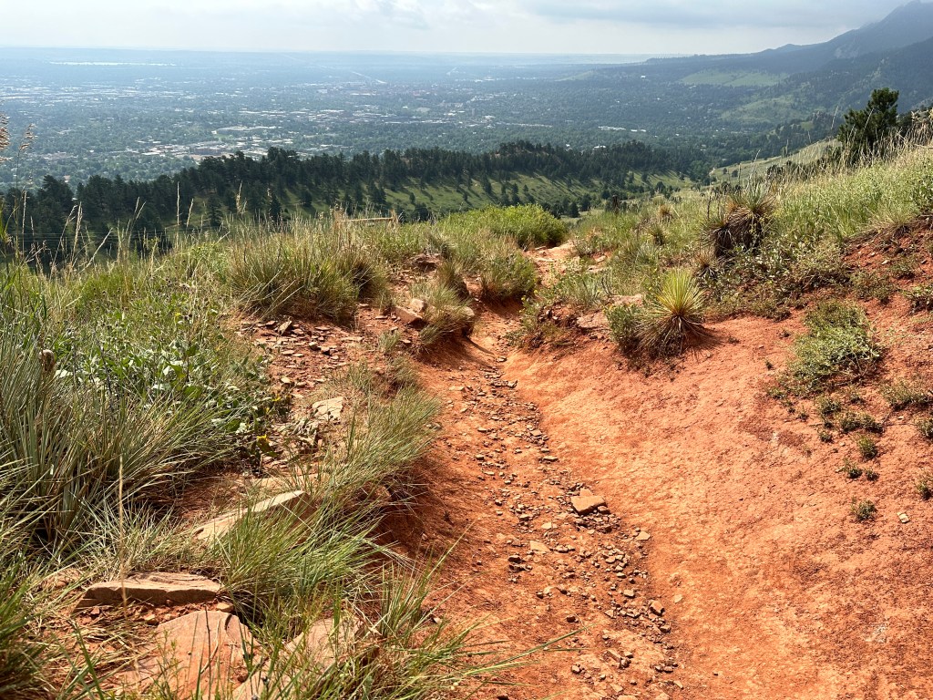
If you decide to go right and take the East Ridge Trail up, you will find it is a very pleasant path. The first 15 minutes or so is a wide dirt path with pebbles. Once you arrive at the end of the Sanitas Valley, the trail will turn left and you’ll begin the ascent along red dirt switchbacks. There are not a lot of large rocks or boulders on this part of the path; it is pretty clear and clean.
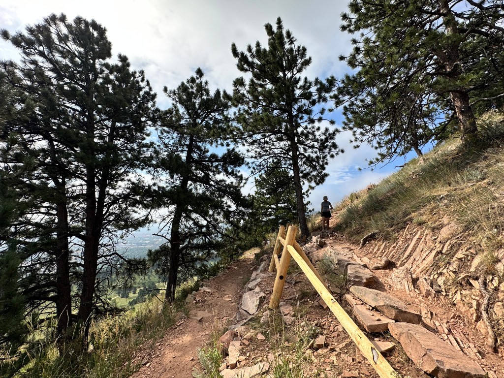
After about 20 minutes of hiking up the switchbacks with little tree cover, you’ll eventually find yourself under what feels more like a forest. The trees will get thicker, and the trail will narrow a bit more. For the last 20-30 minutes you will walk through some larger boulders that are along the path until you eventually reach the peak of Mount Sanitas.
This path is definitely the easier way to go both up and down. This is generally the path I take going down as it is not so steep and much easier on the knees.

If you go left at the Mt Sanitas trailhead (Mount Sanitas Trail)
If you’re looking for more of a challenge, then go left at the Sanitas Trail Map. You’ll feel the elevation rising immediately as the trail starts out quite steep. The first part of the Sanitas Trail will take you through the forest and trees as you make your way up. There are some stairs and rocks to step over.
There are a few spots along the trail that flatten out for a few minutes as you make your way along. However, that is alternated with large red rocks that you’ll need to navigate over, sometimes needing to use your hands. As you continue along the second half of the path, you’ll really notice the height with some pretty incredible views of Boulder down below. There are several parts of this path that will require you to step over large boulders as you ascend. As you approach the peak of Mount Sanitas, the terrain will be quite rugged, and large steps over rocks will be required. Give it your final push to reach the peak.
I usually go up the Mount Sanitas Trail, but I do not take it back down. The reason is because it is so steep, it puts a lot of pressure on my knees. I prefer to take the East Ridge Trail back down. It is easy to find just on the other side of Mount Sanitas Peak (where the pole sticks up).
Is Mount Sanitas a Hard Hike?
In short, yes. Mount Sanitas is definitely a challenging hike due to its steep ascents and rocky paths. You will sometimes need to use your hands to climb over some rocks; you’ll need to take big steps over boulders. But you can always stop and look around at the views that make it worth it!
If you want to see the peak of Mount Sanitas but don’t feel like you can take the Mount Sanitas Trail, then no worries. Just take the East Ridge Trail up to the top.

What to Wear when Hiking Mount Sanitas
The Mount Sanitas Trail in Boulder is pretty tough, so you should dress accordingly to protect your ankles and knees along the trail, and your face from the sun. Here are a few suggestions:
- Simple athletic shoes/hiking boots
- Comfortable hiking socks
- shorts/pants – I love Kuhl hiking pants
- Athletic top that wicks away sweat
- Light jacket if you go early in the morning or in the evening (I LOVE the Cotopaxi windbreaker)
- Fleece in the winter or early spring.
- Sunglasses
- Hat- my favorite is from Cotopaxi

What do Bring when Hiking Mount Sanitas
Check out my blog post about the best hiking gear for beginners.
The trail may take you 2-3 hours, so don’t forget these things:
- Water bottle
- Water bottle sleeve to easily carry your bottle without hands
- Sunscreen SPF
- Hip bag (for keys, chapstick, phone, etc.)
- SPF Chapstick
- Step counter watch
- Your phone to take photos
- Snacks (great for enjoying at the peak)
Tips for Hiking the Mount Sanitas Trail in Boulder
- Go early in the morning as it gets hot in the afternoon.
- Park in the small lot on the north side of Mapleton Street
- Alternatively, park at the Centennial Trailhead lot (or along Mapleton if it’s full).
- Remember to bring water and SPF.
- Many great photo opportunities around.
- Dogs are allowed in the area, but only on a leash.
- Go left for a challenge, right for an easier hike
- Stand aside and let other hikers pass if they approach behind you quickly.
- Uphill hikers always have the right-of-way; stand aside for them.
- Take your trash with you.
- Don’t forget to carry out your dog’s poo bags.
- There are bathrooms in the Centennial lot.
- Make sure to have snacks to enjoy at the peak.

Looking for a Longer Hike? Mount Sanitas Trail Add-ons:
There are a few other trails that you can add-on to your Sanitas Valley hikes. See below for more.
Dakota Ridge Trail
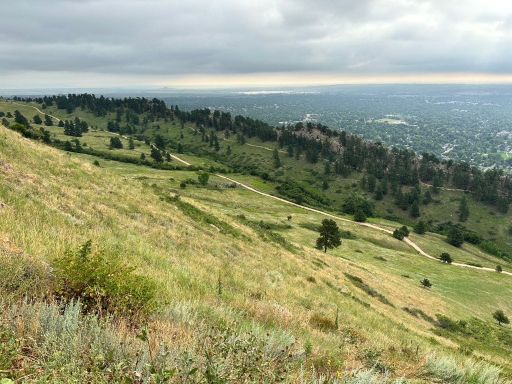
If you look at the photo above, you can see two trails. The main trail going through the valley is the East Ridge Trail. But if you look just above that you’ll see a smaller trail that goes along the ridge. That is the Dakota Ridge Trail. The two paths converge both at the top of the Sanitas Valley, as well as at the bottom where the trailhead is. The Dakota Ridge Trail will have more tree cover and is slightly higher in elevation, whereas the East Ridge Trail is more open to the elements as it goes right through the center of the Sanitas Valley.

Goat Trail
The Goat Trail is a smaller trail that goes along the edge of the hill you can see in the photo below. It is just .6 miles long and connects a residential part of Boulder (Hawthorne Avenue) to the top of the Sanitas Valley. It’s pretty wide open and exposed. The path is narrow and steep.

Anemone Loop Trail
You can easily access the Anemone Loop from Mount Sanitas by crossing over Mapleton Street and following signs to the Red Rocks Trail from the Centennial trailhead parking lot. The entire Anemone Loop from Centennial trailhead parking lot and back is about 3.4 miles.
Lions Lair Trail
If you’re looking to lengthen your hike to the peak of Mount Sanitas, consider taking the Lions Lair Trail. You can follow the same parking instructions as Mount Sanitas. Then start at the Centennial Trailhead and follow signs for the Sunshine Canyon Trail. Take that trail west until you eventually cross Mapleton Street. Then begin to look for the signs that say to Lions Lair. It’s a great hike that will eventually lead you to Mount Sanitas Peak.
Where to Stay in Boulder near the Mount Sanitas Trail
If you have come to visit Boulder to be close to nature, here are a few suggestions for the area:
Hotel Boulderado
Description:This is an historic hotel in downtown Boulder, one of the town’s oldest. It’s located just one block off of Pearl Street. You can easily walk to the Red Rocks Loop trail from here. There is a restaurant and bar on-site, though there are several around in the area as well.
Price: Rooms range in price from $250-$400 in the summer, and around $100 less in the winter.
Foot of the Mountain Motel
Description:This motel is located just next to Eben G Fine Park and about a 5-minute walk from the Red Rocks Spur Loop trailhead. Bike rentals are also available. Breakfast is included. One free parking space is allotted to each room. This place is highly recommended by friends who have stayed here.
Price: Rooms are around $200 – $300/night in the summer and can go as low as $125/night in the winter.
Boulder Adventure Lodge
Description:This is a self-described “convening point for the outdoor-minded.” This is a hostel and community space that offers private rooms as well as dorm beds, though the hostel room is specifically for out-of-state travelers.
Price: A bed in the hostel dorm room runs about $60/night, while the private rooms can go from anywhere between $200-$300/night.
Mount Sanitas Trail Final Thoughts
There is a reason I keep coming back to this trail. I love it, and I want you to love it too. You haven’t really seen Boulder until you’ve looked down upon it from the peak of Mount Sanitas. It’s the right amount of challenge in the right amount of time, and it is highly recommended by me!


TRAVELING SOON?
INSURANCE: Cover yourself with travel medical insurance by SafetyWing.
FLIGHTS: Get the best flight deals with Skyscanner and set flight alerts with Hopper.
STAYS: Check out hotels and apartments with Booking.com and Vrbo.
RENTAL CARS: Get the best deal on rental cars with Discover Cars or RentalCars.
GOING HIKING? Get a 30% discount off your yearly AllTrails+ Account (code: nickiposts30)
eSIM: Get an international eSim with Airalo.
CITY GUIDES: Save time and purchase pre-made city guides with Thatch.
CITY TOURS: Book your tour with GetYourGuide and Viator
LUGGAGE: Get the best carry-on suitcase here.
CREDIT CARD: Start earning travel points with the best travel credit card.
BUENOS AIRES GUIDE: Purchase my Buenos Aires travel companion here.
CONSULTATION: Book a 1:1 travel consultation with Nicki here.
SUBSCRIBE: Get the Nicki Posts Travel Stuff newsletter every month.
TRAVEL BETTER: Check out my Travel Tips and best Travel Resources pages.
MORE? Check out more on my LINKS page to find me in more places!


You must be logged in to post a comment.